The National Hurricane Center has put out projection models for Tropical Storm Isaias, putting it in the Virginia/D.C./Maryland region on Tuesday.
Stock up on batteries and have your storm plan in place. Tropical Storm Isaias is on its way up the East Coast, and it seems to be headed our way.

Tropical Storm Isaias only reached Category 1 hurricane status before being down-graded off the coast of Florida over the weekend, but it will still pack a punch in low-lying areas in our region. Flood-prone regions should consult with their local municipalities for preparation plans.
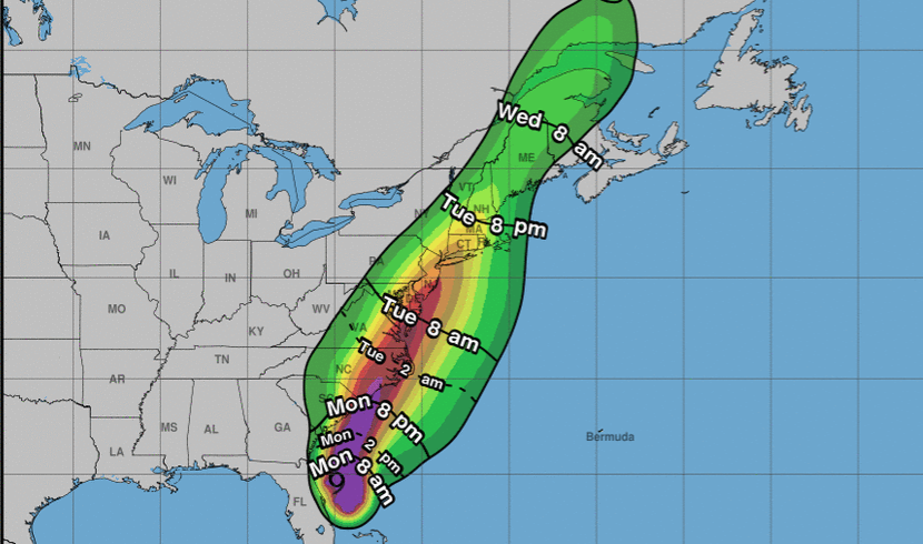
The cone model below shows the predicted path of the center of the storm, and it currently has it hugging the coastline until it reaches Maine on Wednesday afternoon.

Flash floods and power outages are just two of the things to watch out for as we all keep an eye on the storm. A tropical storm is characterized by sustained winds from 39 to 73 miles per hour, so you'll want to secure any outdoor furniture or loose objects around your home. You're better safe than sorry when it comes to potential projectiles!
For more information on the storm, stay tuned to the National Hurricane Center's Facebook page for constant updates. You can also follow their Twitter feed for real-time news.
Here are the 5pm EDT key messages for #Isaias. Tropical storm conditions will spread northward across the U.S. east coast through mid-week. Hurricane conditions are possible Monday night for a portion of the South Carolina and North Carolina coasts. https://t.co/tW4KeFW0gB pic.twitter.com/us9X1c3jVv
— National Hurricane Center (@NHC_Atlantic) August 2, 2020
*The infographics in this article are courtesy of the National Weather Service and National Hurricane Center.
How do you prepare for a big storm? Let us know what you keep in your storm prep kit in the comments. Stay safe, everyone!